|
Furuno SC70 Satellite Compass
High accuracy Satellite Compass with a compact
2-sensor antenna. Uses GPS, Galileo and/or GLONASS satellite systems to ensure
the highest precision and coverage. 0.4 degree course accuracy
Precise and Accurate Heading
The SC70 and SC130 are the latest satellite compasses built on FURUNO’s
commercial-grade technology platform. These satellite compasses prove their
value by increasing the accuracy of other devices, such as Radar, ARPA, Scanning
Sonar, Current Indicator, Chart Plotter, ECDIS and Autopilots. They provide a
highly accurate heading input to these other technologies by utilizing the very
latest GNSS (Global Navigation Satellite System). This satellite system is
comprised of GPS, Galileo and GLONASS to ensure the highest precision and a
continuous coverage.
Bow and Stern Monitoring for Safe Berthing
The Satellite Compass provides a variety of data, including GPS Positioning, SOG
(Speed Over Ground), COG (Course Over Ground), ROT (Rate Of Turn) and 3-axis
speed (bow, stern and longitudinal). All of these data assist with critical
maneuvers, such as berthing. The Compass is maintenance-free - a great asset for
any vessel - and connects easily into the existing shipboard network via
Ethernet connection.
IMO Type Approved as THD, GPS and ROTI
The SC70 provides highly accurate heading data of 0.4° for autopilot, Radar,
ARPA, Scanning Sonar, Current Indicator, Chart Plotter, ECDIS and Autopilots. It
is ideal for small to medium boats requiring highly accurate heading, and is IMO
Type-approved as THD, GPS and ROTI, complying with the IEC/ISO requirements. It
features a rapid follow-up rate 40°/s, twice the IMO high-speed craft
requirement of 20°/s.
Specifications
| General |
| Receiving
frequency |
1575.42 MHz (GPS/Galileo), 1602.5625 MHz
(GLONASS) |
| Tracking code |
C/A code (GPS), E1B (Galileo), 1OF (GLONASS)
|
Positional accuracy
(dependent on ionospheric
activity and multipath) |
GPS 10 m approx. (2drms, HDOP<4)
DGPS 5 m approx. (2drms, HDOP<4)
WAAS 3 m approx. (2drms, HDOP<4)
MSAS 7 m approx. (2drms, HDOP<4) |
| Ship’s speed accuracy (SOG) |
0.02 kn RMS (tracking satellites 5 or
more) |
| Ship’s speed accuracy (VBW,
SOG) |
0.2% of ship’s speed or 0.02 kn
whichever is the greater (tracking satellites 5 or more, at antenna
unit) |
| Course accuracy |
SC-70 0.4° RMS, SC-130 0.25° RMS |
| Course resolution |
0.1°,0.01°,0.001° typical (select from
menu) |
| Tracking bearing |
40°/s |
| Position fixing time |
90 s approx. (typical) |
| Attitude accuracy |
Pitch/ Roll: 0.4° RMS |
| Attitude resolution |
0.1°,0.01°,0.001° typical (select from
menu) |
| Rate of turn |
0.1° ,0.01, 0.001°/min typical (select
from menu) |
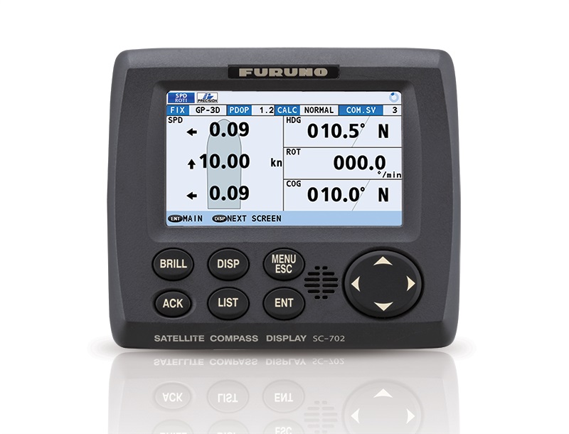
| Display Unit |
| Screen |
4.3-inch color LCD, 95.04 mm (W) x 87.12
mm (H) |
| Resolution |
480 x 272 dots (WQVGA) |
| Brilliance |
600 cd/m2 typical |
| Contrast |
17 levels |
| Display mode |
Heading, Nav data, Rate of turn and
Speed modes (Non-IMO mode only) |
| Visible distance |
0.65 m nominal |
| Interface (Junction Box) |
| Number of ports (junction
box) |
| IEC61162-2: |
1 port (IN: 1, OUT: 1) |
| IEC61162-1: |
8 ports (IN: 4, OUT: 8) |
| External beacon input (DATA5
port): |
RTCM SC-104 V2.3 (RS-485), ITU-R M823 |
| CANbus: |
1 port |
| AD-10: |
4 ports, for heading output |
| RS-485: |
1 port, for display unit connection |
| LAN (IEC61162-450): |
Ethernet, 100Base-TX, RJ45 connecter |
| Data sentences |
| Serial data |
Input |
ACK, ACM, ACN, HBT, HDT*1,
MSK, MSS, THS, VBW*2, VDR*2 |
| |
Output |
ALC, ALF, ALR, ARC, DTM, GBS, GGA, GLL,
GNS, GRS, GSA, GST, GSV, HBT, HDG*2, HDM*2, HDT*1,
HRM*2, MSK, POS, RMC, ROT, THS,VBW*2, VDR*2,
VHW*2, VLW*2, VTG, XDR*2, ZDA |
| Ethernet data |
Input |
ACK, ACM, ACN, HBT |
| |
Output |
ALC, ALF, ALR, ARC, DTM, GBS, GGA, GLL,
GNS, GRS, GSA, GST, GSV, HBT, HDG*2, HDM*2, HDT*1,
HRM*2, POS, RMC, ROT, THS, VBW*2, VDR*2,
VHW*2, VLW*2, VTG, XDR*2, ZDA |
| Output proprietary
sentences |
PFEC GPatt, GPhve, GPimu, pireq, IIalr,
pidat |
| PGN |
Input |
059392/904, 060928, 061184,
126208/720/996 |
| |
Output |
059392/904, 060928, 061184, 065280 ,
126208/464/720/992/996, 127250/251/252/257/258,
129025/026/029/033/044/291/539/540/545/547,
130310/312/314/316/577/578/822/823/842/843/845/846 |
| IEC61162-450 transmission
group |
| |
Input |
MISC, SATD, NAVD, PROP |
| |
Output |
Arbitrary (default: SATD) |
| Other network function
excepted IEC61162-450 |
NTP, HTTP |
*1: Not used for
SOLAS vessels.
*2: for Non-IMO types only. |
| Power Supply |
| Junction box |
12-24 VDC: 2.1-1.1 A
(included antenna unit and display unit) |
| Rectifier (PR-240, option) |
100-115/220-230 VAC, 1 phase, 50-60 Hz
and 24 VDC |
| Environmental Conditions |
| Ambient temperature |
Antenna unit -25°C to +55°C (storage:
+70°C )
Display unit/ Junction box -15°C to +55°C |
| Relative humidity |
95% or less at +40°C |
| Degree of protection |
Antenna unit IP56
Display unit IP22 (IP35: option)
Junction box IP20 (IP22: bulkhead mount) |
| Vibration |
IEC 60945 Ed.4 |
What's in The Box
- SC701 - Junction Box
- SC702 - Display Unit
- SC703 - Antenna Unit
- Installation Materials
|